M24 Burials
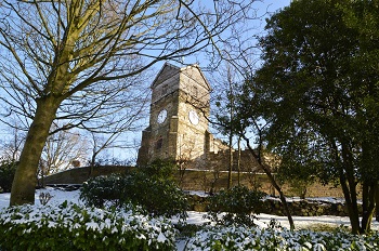
St. Leonard's Parish Church
There is a lot of confusion regarding burials at St. Leonard's as the large cemetery adjacent to the church is actually two different cemeteries. If you stand at the main entrance and look left and right, you will notice two square pillars in the wall. These mark the extent of the Church cemetery. Enter the cemetery and at the end of the short path bear right onto the tarmac path. When you are parallel with the pillar, you will notice a column of graves that are aligned North/South. These run to the pillar and again mark the extent of the Church cemetery. The same applies on the Left. The path forms a large square area in the centre of the cemetery all graves in this square are the Church cemetery and the area outside the square are the municipal cemetery. This central area is Churchyard No3.
Layout
As well as the area described above, the church has two earlier
graveyards within the walls of the church building. Churchyard No1
was the original burial ground and includes burials within the
church building.
Each of the Churchyards is numbered, and in the search function, the yard number is shown in the "Suffix" column.
Churchyard No1
Churchyard No1 is the original area within the walls of the church and includes burials within the church building itself.
The parish records of Middleton start in 1541. These registers were published in book form by the Lancashire Parish Register Society and were described in 1905 as "One of the very best preserved and written with which our society has yet dealt". There are a number of years where the registers have not survived, however, as well as the registers, copies were made and sent to the Bishop. These "Bishops Transcripts" have filled in some of the missing gaps.
Until the 1600's grave markers were rarely used, except by the most wealthy, so although we have records of burials, the location is not known. Like many other churches and burial grounds, stones have been removed from inside the church itself, whilst others have been moved to a new position. The grassed area to the south of the church contains burials, but the stones now form the walkways around the building. It is unlikely that any of the stones in this area are in their original position.
Even in the parish records from the 1900's, burials in Churchyard
No1 are usually recorded with just a reference to the Churchyard,
rather than an individual grave number. For this reason no attempt
will be made to identify the grave locations.
In order to aid the visitor to find extant stones, the Churchyard has been remapped, split into areas and each stone recorded with a new number. Within the search page Section will show the area, Plot is the individual number in that area and Suffix will be "1" to indicate Yard 1. for example NP 57 1 is North Path, stone 57, Yard 1.
| SP | South Path | Stones along the South side of the church building and the path from the South gate to the vestry door. |
| EP | East Path | From the North gate past the tower to a drainage channel. Stones to the left of the North gate, stones on the path to the North porch. |
| ST | South Triangle | The triangular path from the South gate to the South porch. Stones to the West of the porch as far as the drainage channel. |
| NP | North Path | All stones to the North of the church, including alcoves, the Hopwood Vault and two stones outside the North porch. |
| WP | West Path | Stones to the West of the lawn, along the West of the building as far as the steps leading to Yard 2. |
| IN | Inside | All stones within the building itself. |
Follow the link at the top of this page to Yard 1, then the link to the relevant area for maps of the layout.
Churchyard No2
Churchyard No2 is located to the East of the church and is accessed from a path adjacent to the South gate or by steps at the East end of the North path. It was opened for burials in 1787.
The graves are numbered in rows and columns. The search page will give a 3 figure reference, the first number is the column, the second is the row and the third will always be "2" to indicate Yard 2. There are 11 columns running South to North with Column 11 closest to the Church and 1 against the East wall. The row numbering starts at the South, therefore if you enter from the South Path, the first grave you see is 11-1-2 (Column 11, Row 1, Yard 2.
Follow the link to Yard 2 at the top of this page to see layout plans.
The yard has been accurately mapped by an aerial survey, however due to tree cover the South West corner and parts of columns 1, 2 and 3 needs to be accurately plotted, these are shown in pink on the plan. Some movement of the stones has occurred over the years so rows and columns are not perfectly aligned.
Churchyard No3
Churchyard No3 is located to the South of the church.
The graves are numbered in rows and columns. The search page will give a 3 figure reference, the first number is the column, the second is the row and the third will always be "3" to indicate Yard 3. There are 30 columns with 1 to the West. The row numbering starts at the South. If you enter the yard via the main entrance opposite the Church, the path is row 16. 15 is to your left and 17 to your right. Rows 8 to 21 extend to the North wall with the other ending at the tarmac path. On rows 1 and 30 the graves are orientated North/South to mark the edges of the Church cemetery, the same applies on rows 8 and 21 at the North end
In order to find a specific grave, enter the yard from the main entrance, follow the path and bear left onto the tarmac path. Turn right and follow this path to the end. The grave to your right is 1-1-3. (Column 1, Row 1, Yard 3) Turn right and count the columns. Once you have the correct column, enter the yard itself and count the rows. Please note that all plots are numbered, but not all contain a stone, so count the empty spaces.
Links to each of the churchyard descriptions and maps are at the top of this page.